Why is the City hellbent on spending millions to build an in-town dam?
Special Investigation by Skip Foster, Red Tape Florida
The City of Tallahassee wants to build a massive new dam next to Cobb Middle School.
The question is why.
Depending on the option selected, the project could create a wall as much as 27 feet high and roughly 240 feet long — about the same area as Florida State University’s largest Doak Campbell Stadium video board.
The City estimates the project will cost about $5 million, though experts contacted by Red Tape Florida believe the final price could be substantially higher.
And one of the City’s own maps carries a warning that, if selected, the project would flood the Cobb Middle School athletic field during severe storms.
But here is the real head-scratcher.
This is a dam in search of flooding.
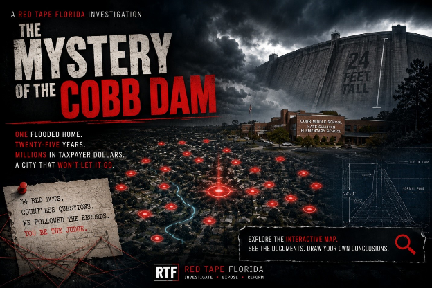
To justify the project, the City has assembled a map containing 34 red dots representing what it calls “reported stormwater problems.” It has cited flooding concerns throughout the area. It has persuaded community leaders that the project is urgently needed. And it is advancing a proposal that differs dramatically from the recommendation contained in its own earlier engineering study.
There is just one problem.
After reviewing a quarter-century of flooding complaints, engineering reports, studies, emails and public records connected to those 34 properties, Red Tape Florida found a collection of facts that are difficult to reconcile with the City’s narrative.
Residents included on the map say they should not be there.
Several red dots represent vacant City-owned lots.
The City’s own consultant once recommended a different solution.

And according to City records, only one home — a rental duplex on a lot which had recently been sold by the City to a private developer –experienced documented in-home flooding associated with this drainage system.
That flooding happened in June of 2001.
Before Facebook.
Before smartphones.
Before 9-11.
The question bears repeating:
Why is the City of Tallahassee so intent on building this dam?
Welcome to the Mystery of the Cobb Dam.
34 red dots
Kimberly Studley really didn’t understand. She had experienced some minor stormwater issues on her property on McClendon Drive but was told by the City that it had nothing to do with the dam project.
Yet, she discovered that her home was a “red dot” on the City map entitled: “HILLCREST & LUCY STREETS STORMWATER IMPROVEMENTS REPORTED PROBLEMS & FLOOD EXTENTS.”
Here is what Studley wrote to the City:
I recently learned despite the city staff themselves telling me my flooding issue was completely unrelated to the project, my property was then added to the dam project’s map as one of the “35 properties reporting stormwater issues” represented by a red dot. I understand that there are numerous other red dot properties on the project map like mine with flooding issues completely unrelated to anything the dam is supposed to fix. This has already misled the civic process and calls into question the project’s fiscal justifiability, especially with city-owned properties on Sauls Street available for use, not requiring the building of an expensive dam.
That was in November of 2025.
The Studley home is still a red dot on the City’s web site justifying the dam.
There are a total of 34 dots on the map the City still has on its web site. Only 16 of them were on the red- and purple-colored areas on the map labeled as areas that are “flood extents” either now or after the dam is erected.
But the map has obvious and deep flaws.
Here is one of them – three red-dotted properties near the intersection of Saul Street and Spottswood Drive – are empty lots.
The lots’ owner? The City. The three lots were purchased 10 years ago. Why would the city be including vacant, government-owned lots on a graphic justifying the construction of a multi-million-dollar dam?
A 34-dot breakdown
Here is a more detailed breakdown of the “red dots” which the City labels as “reported stormwater problems” on its map included in materials supporting the construction of the dam.
- A dot in the Sequoia Drive area includes a resident complaint in 2024 that a pond at the end of Belmont Road was not being maintained and had become “a nesting site for rats.” The city found it was not a pond, but an undeveloped lot. An earlier 2002 finding on the same house from the City concluded: “The house does not have chronic flooding problems.”
- A flood report in 2012 from a home on Devil’s Dip resulted in a visit from City officials who concluded “the flood was probably mainly due to seepage.” In other words, it had nothing to do with the drainage ditch to her south. The city official also pointed out that the homeowner’s gutters needed work.
- A recurring theme is the ditch that runs from near Cobb all the way southeast, under Mahan to the neighborhood just northeast of the former home of the Tallahassee Democrat on Magnolia. The ditch often became clogged with debris. Ditch maintenance would obviously be millions of dollars cheaper than a large dam.
- Another of the complaints was from a Brookwood Drive resident, who reported water in her yard overflowing from the ditch. The homeowner included pictures. But the City’s response was telling: “I called her back on August 6, 2018, and said that this was private property with no easements for drainage.” Three years later, after another complaint, the City decided it would work on the problem and sent out a crew to clear the ditch and drains.
Twenty of the dots reference flooding from Tropical Storm Allison which plagued Texas and much of the southeast with copious amounts of rain as it meandered along the Gulf Coast in June of 2001 … more than 25 years ago. For perspective, Tropical Storm Allison led to the wettest 24-hour period in the recorded history of Tallahassee weather. More than 10 inches of rain fell – a once-in-a-century flood.
Rather than asking readers to take our word for it, Red Tape Florida is publishing the City’s map and has made it interactive with links to the underlying records used to justify it. Review them yourself. Then decide whether they support construction of a jumbotron-sized dam.
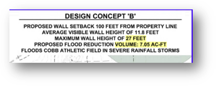
You can also check out the City’s own design concept maps here, including Design Concept B, which includes a reference to the Cobb’s athletic fields flooding if one option is selected.
2010 recommendation: No dam
The City of Tallahassee’s current push for a dam near Cobb Middle School is especially noteworthy because it differs from the recommendation contained in the City’s own 2010 engineering study. That study, prepared by GPI Southeast, a division of one of the nation’s larger engineering firms, examined flooding concerns in the area and evaluated multiple potential solutions.
GPI concluded that the most appropriate course of action was not an upstream dam on school property, but rather a series of critical maintenance and safety upgrades to the existing drainage system. The firm found that those improvements could be completed within existing City rights-of-way, without acquiring land, obtaining major permits, or constructing a new stormwater facility.
Did City Hall give Rocky Hanna bad information?
Responding to criticism of the City’s stormwater spending, Leon County Schools Superintendent Rocky Hanna told the Tallahassee Democrat last spring: “I think the person that is raising this issue needs to have a conversation with the residents downstream that are being flooded out of their homes every time there’s a major storm.”
That is a powerful image.

It is also completely unsupported by the City’s own records. If residents were being “flooded out of their homes every time there’s a major storm,” the City should be able to document that clearly.
Where are the records?
Where are the repeated home-flooding reports?
Where are the addresses?
Where are the damage claims?
The City’s own “red dot” map shows that the last time someone in the affected area was “flooded out of their home” because of the drainage ditch overflowing was 25 years ago on a day when Tallahassee received more rain than any time in its recorded history.
Hanna may have been acting in good faith. He may simply have repeated what City officials led him to believe.
But if the City’s own records do not support the claim that residents were being flooded out of their homes every time there is a major storm, then Hanna deserves better information — and residents deserve better answers.
Flooding is serious. So is misleading the public – and superintendents – about it.
Fifteen years later, the City is pursuing a far more ambitious approach. The current proposal, developed with assistance from local engineering consultant Eutaw, would require construction of a large stormwater impoundment adjacent to a school campus, along with easements, environmental permitting, floodplain mitigation, and long-term maintenance obligations.
Of note, since the 2010 recommendation, Tallahassee experienced another major flooding event – the “Bicentennial Storm” of April 11, 2024. The City created a web page to document the 42 structures that flooded from that storm, including Godby High School. Guess how many of those structures fell into the area impacted by the proposed dam?
None.
Pay a Tallahassee utility fee? This section is for you
The City of Tallahassee is not approaching stormwater with a skeleton staff. According to the City’s own budget materials, Stormwater Management has a 2025-26 operations budget of $12,989,898, with 21 employees assigned to Stormwater Management and another 67 employees in Drainage Operations.
That does not mean the City should never hire outside engineers. Complex stormwater modeling, design and permitting often require specialized consulting work. But the scale of the City’s own stormwater operation makes the Cobb Dam’s long and winding path harder to understand, not easier.
City checkbook data reviewed by Red Tape Florida shows that Eutaw, the local engineering firm now associated with the Hillcrest & Lucy stormwater project, has received $3,389,961.39 from the City since 2018 across 269 payments. Of that, $59,970.75 is identified in the City’s checkbook as payments for “Hillcrest & Lucy St Stormwater.”
That may be the real mystery of the Cobb Dam. How did a City with a nearly $13 million stormwater operation, 88 stormwater and drainage employees, and multiple outside engineering consultants end up pursuing a major new dam on school property after an earlier City-commissioned study recommended a simpler path?
Now, the questions
Tallahassee utility customers are left with a lot of questions:
If the City claims there is a widespread flooding crisis that justifies a large new dam, where is the proof of it?
If the red-dot map is intended to demonstrate need, why do so many of the underlying records appear unrelated to the project?
If the problem is as urgent as City officials suggest, why did the City’s own consultant recommend a different solution in 2010?
If one documented in-home flooding event in the affected area occurred 25 years ago during a record-setting storm, what exactly is the emergency?
And perhaps most importantly:
Why does the City seem so eager to spend the millions and millions of dollars it will require to construct a dam that abuts two public schools?
That last question is the one that lingers.